


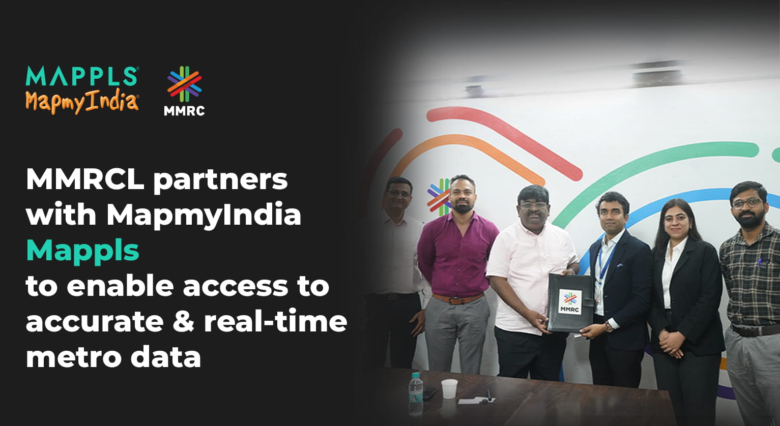
- Over 45 Million Mappls App users to benefit with real-time Mumbai Metro information like routes, fares and train frequencies at a glance
- The integration of Mumbai Metro Line 3 (Aqua Line) into the Mappls App will enable seamless end-to-end journey planning across the metro network, supporting a more connected travel experience in Mumbai.
Delhi, October 14, 2026: Mumbai Metro Rail Corporation Limited (MMRCL) today signed a Memorandum of Understanding (MoU) with MapmyIndia Mappls, India’s leading digital mapping and deep-tech company, to integrate Mumbai Metro data into the Mappls App. The integration will enable commuters to discover Mumbai Metro Line 3 (Aqua Line) stations, explore routes, access information on fares and train frequencies, and plan seamless end-to-end journeys from origin to destination through the Mappls App. By making official metro information readily available on a single platform, the collaboration will benefit daily commuters, residents, visitors and tourists, helping them make informed travel choices and navigate the Aqua Line network with greater ease and convenience.
Commenting on the partnership, Shri R. Ramana, Director (Planning & Real Estate/NFBR), MMRCL, said, “Mumbai Metro Rail Corporation is committed to making metro travel more accessible, convenient and technology-enabled for commuters. The integration of Mumbai Metro Line 3 (Aqua Line) information into the Mappls App will help commuters plan their journeys more effectively, navigate the network with ease and access relevant travel information at one place. Our partnership with MapmyIndia marks another step towards delivering a smarter and more seamless metro experience across Mumbai.”
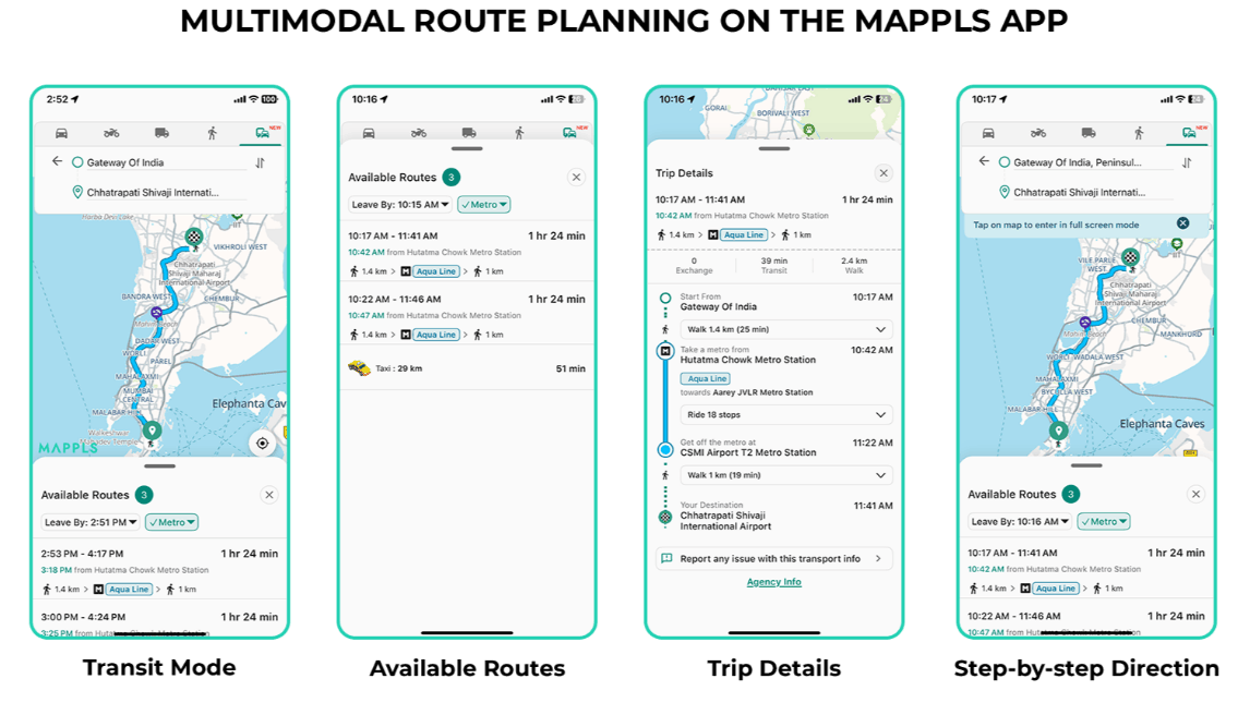
Mr. Rohan Verma, Joint Managing Director, MapmyIndia Mappls, said, “We are happy to partner with Mumbai Metro Rail Corporation to make official information easily accessible to Mumbaikars and those traveling to the city. Starting with Mumbai Metro Line 3 (Aqua Line), the Mappls app will now be their Metro Guide and offer accurate/real-time enabling commuters to efficiently plan their journeys and access the Mumbai Metro network with greater ease. This collaboration demonstrates the role of Swadeshi technology is facilitating smarter urban mobility and reinforces MapmyIndia Mappls commitment towards an Aatmanirbhar and digitally connected India.”
The partnership brings together MMRCL’s authoritative metro information and MapmyIndia’s indigenous maps and location technology. Once integrated, Mumbai Metro Line 3 (Aqua Line) information will be accessible to over 45 million Mappls App users in real-time, making it easier for commuters to access official information and plan their metro journeys with confidence:
- Metro Station Data (Geotagged Location, facilities such as parking for cars,
- bikes, etc)
- Mumbai Metro Network (colour of lines, line changes, etc)
- Frequency of trains
- Fare Prices
- Number of stations and lines
Additional notes about Mappls App:
- The free indigenous maps & navigation app Mappls App can be experienced atcom and downloaded from mappls.com/getApp
- Reduces travel time, costs, hassle, and road accidents, critical in the Indian context, making it the best maps and navigation app for all Indians.
- Mappls App is free, fully indigenous and is far better than those foreign maps that come preloaded with most phones and search engines, which incorrectly depict India’s international boundaries, give inaccurate routes and search results, show junk places at incorrect locations on their maps, and prey on users’ private and personal data to target them with ads. Mappls App on the other hand shows India’s borders correctly, is highly accurate, and has a clean business model that respects users’ privacy – the only thing users need to do is download the Mappls App from the app store or play store, and they can experience a better alternative.
- Mappls helps in road safety and in reducing accidents, critical in the Indian context, by showing the route summary and giving real-time alerts to drivers about upcoming speed limits, speed cameras, speed breakers, sharp curves, accident-prone zones, traffic signals & photo-realistic 3D views of junctions. Mappls is uniquely Incorporated with MoRTH (Ministry of Road Transport & Highways) collected road accident prone zone data and traffic and road closure advisories from traffic authorities, and uniquely Incorporated with ISRO (Indian Space Research Organization) satellite imagery and earth observation data about weather, snow cover and more.
- Mappls offers more detailed and comprehensive coverage of buildings and house addresses, allowing drivers to search exact addresses and reach the doorstep of their destination, without having to call, ask or look around.
- Mappls offers a simple and smart solution to the problem of long, complex addresses and place information sharing for Indians. Mappls Pin is a simple 6-character digital code for (for e.g.mmi000) containing the exact location, complete address and all other relevant, shareable information such as which floor a flat is own and if it is a public place, then its phone number or website etc, enabling hassle-free and literally last-meter navigation and delivery, and a whole host of other enterprise and governance use cases.
- Mappls correctly differentiates routes based on vehicle type (4-wheeler, 2-wheeler, truck etc.), avoiding small lanes for 4-wheelers and trucks for example, and accurate, live traffic congestion info, ensuring drivers arrive on time, without getting lost.
- Mappls give detailed total trip cost estimates including toll gate-wise fees, as well as fuel/battery costs, allowing drivers to plan better & find potentially cheaper routes.
- Along the route, users can search for all relevant facilities such as rest stops, restaurants, ATMs, garages, hotels, ambulances, blood banks and more to ensure the travel is comfortable and hassle-free in case of breakdown or emergency.
- Further, Mappls offers immersive 3D Metaverse and 360-degree RealView maps in hundreds of cities and across lakhs of kilometers across India, allowing drivers to be sure of exactly how a place and route looks in real life.
***About MapmyIndia (C.E. Info Systems Ltd) & Mapplswww.mapmyindia.com / about.mappls.com / www.mappls.com
C.E. Info Systems Ltd (NSE: MAPMYINDIA; BSE: 543425) is India’s leading deep-tech digital map data, geospatial software and location-based IoT products, platforms, solutions and APIs company, offering proprietary digital maps as a service (“MaaS”), software as a service (“SaaS”) and platform as a service (“PaaS”). The company provides its digital maps, software products, platforms, application programming interfaces (“APIs”), IoT and solutions to new-age tech companies, businesses across industry verticals, automotive OEMs, government organisations, developers and consumers, under the Mappls MapmyIndia brand. The company has served more than 2000 B2B and B2B2C customers since inception. The company pioneered digital mapping in India in 1995 and has earned its market leadership position in this industry and built a strong moat by capitalizing on our early mover advantage, developing proprietary and integrated technologies, full stack product offerings, continuous innovation and robust sustainable business model.
MapmyIndia has built India’s most comprehensive, accurate, feature-rich and continuously updated digital map data product down to address and urban building level detail pan India, covering all towns, villages, and the entire road network of the country. The company is building not just 2D maps, but also 3D (with landmarks, terrains and city models), 4D (updating in near real-time), HD (high-definition and high-accuracy), RealView (photo-realistic representing actual ground reality), and hyper-local geo-demographics data-rich maps, to continuously evolve its AI-powered Digital Metaverse Twin of the Real World. The company is also building digital maps for other regions in the world, and has integrated global maps for over 200 countries into its Mappls platform. The company’s platform provides extensive and comprehensive functionalities and ever expanding set of use cases, including mapping, location and navigation, geospatial data analytics, GIS (geospatial information systems) and AI, GPS tracking and IoT-based fleet management, logistics optimisation and workforce management, drone-based solutions, developer APIs, N-CASE solution suite (for Navigation, Connected vehicle telematics and services, ADAS safety i.e. advanced driving assistance systems, Shared and Electric) for Automotive & Mobility Tech (A&M), and Consumer tech and Enterprise digital transformation solution suite (C&E). More about the entire range of the company’s products and platforms can be learned about from about.mappls.com.
The company’s consumer facing products include the free Mappls App (accessible on the web at www.mappls.com & downloadable from mappls.com/getApp), which provides the best and fully indigenous maps, navigation, safety, hyper local and IoT gadget-enabled app experience for users, and Mappls Gadgets (www.mapplsgadgets.com), which provides a range of IoT-enabled gadgets for safety, convenience, entertainment of your vehicles and loved ones such as vehicle trackers, dash cameras, and in-dash and in-helmet navi-tainment systems for cars and 2-wheelers.

 For Solutions : +91-7948 083 370
 For Gadgets : +91-9999 333 223