-
Products
Products
- Map and Data
- APIs and SDKs
APIs and SDKs
-
See all APIs

Explore our entire suite of APIs & SDKs
Maps
SDKs for maps and traffic
Search & Geocoding
APIs for search and discovery
-
Routes & Navigation
APIs to solve complex routing problems
-
Navigation SDK
Connected embedded navigation
Mobility & Tracking
SDK to enable live location in your apps
-
Global APIs
Maps, search, routes for 238 nations
Personalisation SDK
Hyperlocal, personalised O2O marketing
-
Optimisation APIs & SDKs
Route planning & optimisation
GIS and Analytics APIs
GeoBI meets Location AI
Workmate APIs
Field force automation APIs
Mappls App URLs
Embed maps, navigation in your apps
NaviMaps SDK APIs
Hybrid navgation for embedded systems
-
See all
APIs
-
- GIS, Analytics and AI
- IoT and Automation
- Navigation and Mobility
- Digital Twin
- Consumers
- Developers
- Solutions
SolutionsBy Vertical
- Consumer
- Developers
- Developers
Developers
- Map APIs & SDKs
Maps
SDKs for maps and traffic
Personalisation SDK
Hyperlocal, personalised O2O marketing
Search & Geocoding
APIs for search and discovery
-
Routes & Navigation
APIs to solve complex routing problems
-
Navigation SDK
Connected embedded navigation
-
Optimisation APIs & SDKs
Route planning & optimisation
RealView APIs (coming soon)
APIs for 360° panoramic images
- Analytics APIs
- Telematics APIs & SDKs
- Mappls Apps APIs & SDKs
- Advanced APIs & SDKs
- Use Cases
- Documentation
- Demos
- Map APIs & SDKs
- Company
- Resources
- Investors
- Contact us
How Bajaj Auto is offering the future of mobility to
their customers with MapmyIndia’s Maps
and EV Chargers SDK

Bajaj Auto, one of the world’s largest two-wheeler manufacturers, has resurrected and relaunched India’s first indigenous two-wheeler - Bajaj Chetak, but now combined with the next-gen prowess of EV.
With a seamless design and a solid build, Chetak offers customers to stay connected to their vehicle with Chetak App from anywhere, anytime. The app is powered by India’s most comprehensive, updated and accurate MapmyIndia maps - offering the users a smart, safe, convenient and efficient EV two-wheeler customer experience.
Nearby EV Charging stations
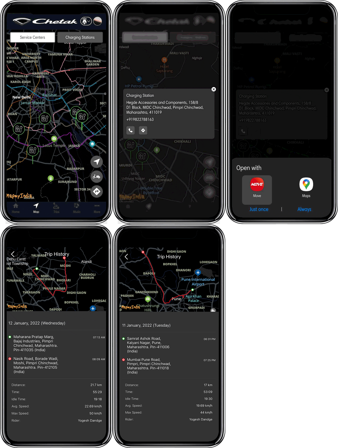
Being the representation of the world around you, maps are one of the essential parts of an EV two-wheeler driving experience. MapyIndia’s rich, hyperlocal and most updated map data library more than lives to the purpose by helping the Chetak App users with the nearby EV charging and service stations. With a tap on the EV stations, they can find out the exact address and the contact details provided - thanks to MapmyIndia’s nearby plugin. The users can further select one of the EV stations and choose to navigate using available navigation applications on their phones.


Get the exact address and contact details of the charging station by tapping on the map
Trip History
Not just maps and hyperlocal data, users can also reconstruct their routes
by checking
out the trip history. At the backend, the app uses
MapmyIndia’s extremely intuitive Snap
to Road API which collects GPS
points along a route and returns a similar set of
corrected and aligned
data with the points matched to the road - delivering the users
with an
output of the history of their different trips along with stats and map with
a
simple tap on the “Trip History” tab.


Detailed trip history with the stats and map
MapmyIndia’s revolutionary EV mobility solutions are powered by India’s largest, comprehensive and accurate 4D, time and space map to ensure a smart, safe, efficient, dynamic and scalable solution to optimise the customer experience.
To learn more about them, click here.

