-
Products
Products
- Map and Data
- APIs and SDKs
APIs and SDKs
-
![]() See
all APIs
See
all APIs 
Explore our entire suite of APIs & SDKs
![]() Maps
Maps
SDKs for maps and traffic
![]() Search & Geocoding
Search & Geocoding
APIs for search and discovery
-
![]() Routes & Navigation
Routes & Navigation
APIs to solve complex routing problems
-
![]() Navigation SDK
Navigation SDK
Connected embedded navigation
![]() Mobility & Tracking
Mobility & Tracking
SDK to enable live location in your apps
-
![]() Global APIs
Global APIs
Maps, search, routes for 238 nations
![]() Personalisation SDK
Personalisation SDK
Hyperlocal, personalised O2O marketing
-
![]() Optimisation APIs
& SDKs
Optimisation APIs
& SDKs
Route planning & optimisation
![]() GIS
and Analytics APIs
GIS
and Analytics APIs
GeoBI meets Location AI
![]() Workmate APIs
Workmate APIs
Field force automation APIs
![]() Mappls App URLs
Mappls App URLs
Embed maps, navigation in your apps
![]() NaviMaps SDK APIs
NaviMaps SDK APIs
Hybrid navigation for embedded systems
-
See all
APIs
![arrow]()
-
- GIS, Analytics and AI
- IoT and Automation
- Navigation and
Mobility
Navigation and Mobility
![]() NCASE
Automotive Suite
NCASE
Automotive Suite
Intelligent mobility platform for PV, CV, EV
![]() Navimaps
Navimaps
Offline navigation maps and app
![]() Mappls App
Mappls App
Super app for maps, safety, and more
-
![]() Navigation SDK
Navigation SDK
Connected embedded navigation
-
![]() RouteNet
RouteNet
Connected embedded navigation
![]() Traffic AI
(coming soon)
Traffic AI
(coming soon)
Convert movement data to traffic analytics
- Digital Twin
- Consumers
- Developers
- Solutions
- Consumer
- Developers
- Developers
Developers
- Map APIs & SDKs

 Maps
Maps
SDKs for maps and traffic

 Personalisation SDK
Hyperlocal, personalised O2O marketing

 Search &
Geocoding
Search &
Geocoding
APIs for search and discovery
-

 Routes & Navigation
APIs to solve complex routing problems
-

 Navigation SDK
Connected embedded navigation
-
![]() Optimisation
APIs & SDKs
Optimisation
APIs & SDKs
Route planning & optimisation

 RealView APIs
APIs for 360° panoramic images
- Analytics APIs
- Telematics APIs & SDKs
- Mappls Apps APIs & SDKs
- Advanced APIs & SDKs
- Use Cases
- Documentation
- Demos
- Map APIs & SDKs
- Contact us


- Map APIs & SDKs
- Maps
SDKs for maps and traffic
-
Personalisation SDK
Hyperlocal, personalised O2O marketing
- Search &
Geocoding
APIs for search and discovery
-
Routes & Navigation
APIs to solve complex routing problems
-
Navigation SDK
Connected embedded navigation
-
![]() Optimisation
APIs & SDKs
Optimisation
APIs & SDKs
Route planning & optimisation
- RealView APIs
APIs for 360° panoramic images
-
![]() Custom Search SDKs & APIs
Custom Search SDKs & APIs
Bring and search with your data
- Analytics APIs
- Telematics APIs & SDKs
- Mappls Apps APIs & SDKs
- Advanced APIs & SDKs
- Use Cases
- Documentation
- Demos
- Docs at Github
- Dev Community
- All APIs
Products
- Map APIs & SDKs
- Maps
SDKs for maps and traffic
- Personalisation SDK
Hyperlocal, personalised O2O marketing
- Search & Geocoding
APIs for search and discovery
-
Routes & Navigation
APIs to solve complex routing problems
-
Navigation SDK
Connected embedded navigation
-
![]() Optimisation APIs & SDKs
Optimisation APIs & SDKs
Route planning & optimisation
- RealView APIs
APIs for 360° panoramic images
-
![]() Custom Search SDKs & APIs
Custom Search SDKs & APIs
Bring and search with your data
- Analytics APIs
- Telematics APIs & SDKs
- Mappls Apps APIs & SDKs
- Advanced APIs & SDKs
- Maps
SDKs for maps and traffic
- Personalisation SDK
Hyperlocal, personalised O2O marketing
- Search &
Geocoding
APIs for search and discovery
- Routes & Navigation
APIs to solve complex routing problems
-
Navigation SDK
Connected embedded navigation
-
![]() Optimisation APIs & SDKs
Optimisation APIs & SDKs
Route planning & optimisation
- RealView APIs
APIs for 360° panoramic images
-
![]() Custom Search SDKs & APIs
Custom Search SDKs & APIs
Bring and search with your data
- Map APIs & SDKs
- Use Cases
- Documentation
- Demos
- Docs at Github
- Dev Community
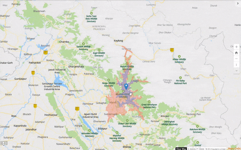
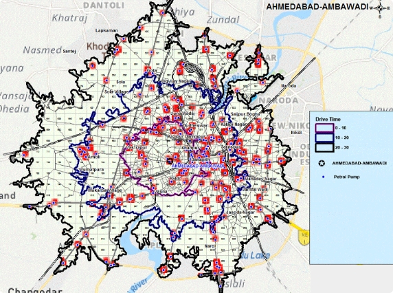
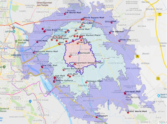
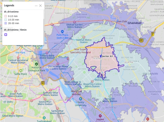
What is Driving Range Polygon API
Driving range polygon API leverages the rich data set of actual street networks available with Mappls to compute reachable areas within a specified time interval or distance from a location and returns the reachable regions as contours, polygons or lines that you can display on a map.
This API provides solution the problem of finding regions and places that are reachable within a pre-defined distance or time.
For example, where all one can reach if one travels 20 km or travels for 45 minutes from an origin location.
Why use the drive range polygon API?
Today, one of the most common and important problems that people and businesses face is - what is reachable from my location?
This can in the form of a wide variety of use cases, such as:
- Where all can my electric vehicle reach from my current location given the current status of the vehicle?
- Where all can my outlets serve if they have to reach the consumer in 10 mins?
etc.
Mappls Driving Range Polygon API solves for such use cases:
This API creates the driving range polygons that use actual street networks + their plethora of static and dynamic attributes that Mappls has accumulated given our extensive experience in solving for automotive use cases.
This API takes in driving time or distance (+ more) and is quickly able to determine how far one can get to, considering both live or historical traffic patterns at the time of departure.
Robust Capabilites

Support different travel modes
Driving range polygon API accommodates different travelling and vehicle modes like - walking, biking, driving, and trucking.

Support for Time and Distance base analysis
Allows the user to conduct time-based and distance-based calculations like - places one can reach within a 5 km range of driving distance.

Ability to generate multiple polygons and visualisation
This API provides multiple polygons in a single response which allows the user to get the response in one go.
This solution can be used to filter answers
and implement a variety of use cases
Solution for range anxiety in EVs
Driving range polygon API is a shoo-in solution to solve the range anxiety in EVs. If one can see the exact place they can reach in the remaining range, there will be fewer apprehensions and more confidence end customers will have in their vehicle. Driving range polygon API will deliver exactly that - create, draw and visualise the regions that the user can reach for the range left right now.
Real-time trip assignment for cab aggregators
Trip and driver assignment is usually done on the aerial vicinity basis instead of actual travel distance and time. They have often observed that they take the unexpected time or deny the ride, leading to a customer complaint or loss to the company.
Driving range polygon API can help identify the appropriate trip/driver assignment with the specified time/vicinity, say 5 min from pickup location.
Property search
Limit search results according to the users’ preferred commute times to work, for example, “show me all available flats within a 15-minute walk from work”.
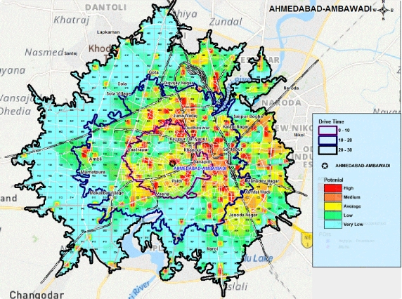
Site Selection: New office/ store location
For relocating a company’s office, one can build reachability maps with desired time for each of the current employees and check if there is an intersection between them. Moreover, one can filter statistics with driving range polygon API and check how many potential customers live in a new site's bounded area.
Delivery/Catchment Area Analysis
Driving range polygon API can help to define the delivery area for a retail outlet. For example, a restaurant wants to categorise its customers with respect to the delivery time of 5, 10 & 15 minutes of driving from the restaurant.

Personalisation SDK, by Mappls, is India's first O2O engagement tool that can 3X your customer engagement, retention and conversion.
There's so much that Mappls MapmyIndia can do for your enterprise or individual requirements. Explore our website to learn more or request a callback/email if you'd like us to connect with you.